Skip to content

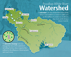
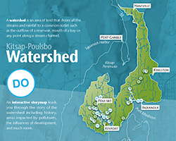
What Is A Watershed?

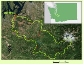
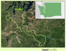
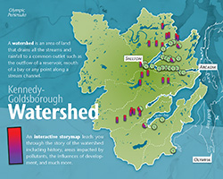
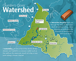
A watershed is an area of land that drains all the streams and rainfall to a common outlet such as the outflow of a reservoir, mouth of a bay, or any point along a stream channel. The word watershed is sometimes used interchangeably with drainage basin or catchment. In our case, it is the Puget Sound.

A storymap is an interactive map that as you navigate the watershed tells the story of that watershed. This can include its history, areas impacted by pollutants, how it is influenced by development, and much more.

EXPLORE YOUR WATERSHED!

Interested In Exploring Your Watershed?

Start by picking a watershed close to you and explore the Story Map associated with it.

The Nisqually Tribe has inhabited the Nisqually Valley for thousands of years. Their livelihood has always depended on the salmon populations that call these waters home. History on the Nisqually River has shown that this important resource was nearly lost in the recent past and continues to be threatened today.
Situated near Olympia, Washington the Deschutes River Watershed drains 162 square miles and runs 57 miles from the headwaters to Budd Inlet in South Puget Sound.
On the slopes of Mt Rainier, the two main tributaries of the Puyallup River form from beneath massive glaciers. The White and the Carbon Rivers flow through wild and untamed wilderness, eventually joining up and becoming The Puyallup River. This watershed covers approximately 1,040 square miles (665,000 acres), ending in the third-largest city in Washington State, Tacoma, where it joins with the Puget Sound.
The history of Poulsbo includes the native Suquamish Tribe that used Liberty Bay for its seasonal harvesting of shellfish and salmon. As the lumber industry grew and more European settlers came to Poulsbo, industry pushed on the boundaries of natural habitat. Water quality has suffered from stormwater runoff and is being addressed by several organizations. Learn more about the Kitsap-Poulsbo watershed here.
Kennedy Goldsborough derives its waters mostly from winter rains with annual precipitation in ranges from 40 to 80 inches per year. The watershed includes a diverse ecosystem of fertile floodplain forests, marshes, and tide flats. Important shellfish farms surround the area but continue to be threatened by water quality in the South Puget Sound. Take a tour of this watershed and be on the lookout for some clues to steer your way.
The native inhabitants including the Steilacoom, Nisqually, & Puyallup Tribes inhabited villages from American Lake, around Pt. Defiance, Commencement Bay to the Puyallup River. All species of salmon were a large part of their culture and food source. The Chambers-Clover watershed seen in this map covers about 95,350 acres in Pierce County. Salmon runs across the Puget Sound have lost species of salmon due to increased pollution and stormwater runoff into the rivers and streams.